|
|
Table
of Contents
Explorations
of the West
Sam
Dalsheimer
Caitlin
Goss
Nick
Schradle
David Sena
Representations
of
Native Americans
Richard
Dybas
Amanda Leong
Cynthia
Robertson
The
Western Railroads
Ronni Toledo
Kayt
Fitzmorris
Jon Ingram
David
Halperin
The
California
Gold Rush
Jordan Helle
Adam
Lawrence
Marisa
Pulcrano
Patrick Ryan
California
as Western Destination/
Mediterranean Boosterism
Maddy
Kiefer
Danielle
Mantooth
Molly
Nelson
Stefanie Ramsay
Back
to Online Exhibits
|
Introduction
From initial surveys of the
territory upon which to build the
railroad to advertisements of new
regions accessible by the railroad,
our four texts outline the evolution
of American conceptions of the
frontier from the mid- to the
late-19th century. Volume XI of the
War Department’s Reports of
Explorations and Surveys of 1853
examines the land between the
Mississippi River and the Pacific
Ocean and the potential for a
cross-country railroad.[more]
Frederick Jackson Turner’s thesis on
the frontier likely stemmed from his
examination of such documents. The
surveyors’ accounts allude to the
frontier as a source of great
adventure in which developers could
help establish new regions by
conquering the savagery of nature.
The addition of such claims to the
Reports suggests an underlying
boosterism and potential for new
beginnings on the frontier. While
obviously written so as to persuade
the War Department to approve of the
construction of the railroads, the
ideas emphasized by the explorers
were later mimicked in
advertisements for the railroads.
Many parts of Crofutt’s
Trans-Continental Tourist Guide of
1871 stress the benefits of the
railroad as a corridor to the West
for pioneers to more easily access
and take control over land. In an
early incarnation of the modern
tourist guide, such claims embodied
America’s notion of “Manifest
Destiny,” of having a divine right
to expand across, and later beyond,
North America. This focus still
shows an extension of Turner’s
theories of the frontier. The
changes occurring out west, however,
can be seen in the depiction of the
far west as the ultimate
destination, rather than the central
territories and states.
Similarly, the Rand McNally’s Guide
to the Pacific Coast of 1893
promotes the West as an ideal
location for settlement which
enabled people to explore new,
entirely different worlds, even just
in traveling from one part of
California to another. While still
somewhat enthusiastic about
adventure, the perceived closing of
the frontier prompted railroad
companies and advertisers to place
less emphasis on the need to
“conquer” the land and more on the
benefits of living in the region.
Nonetheless, the opportunity to
settle in a new region still
portrayed the West, at least
implicitly, as a place to create new
lives and identities. Even when
traveling to unsettled lands, the
railroad became a corridor of
domesticity for which to travel
through foreign spaces.
As exemplified by portions of Health
and Pleasure on “America’s Greatest
Railroad”, railroad companies also
began representing relatively
unsettled areas as locations where
people could get closer to nature.
However, they no longer described
nature as a savage and dangerous,
and thus masculine, but rather as a
place in which people could be
psychologically and physically
rejuvenated. A more therapeutic
ethos took hold and claimed that
people “needed” temporary, rather
than permanent, sojourns to nature
to reduce stress and to renew their
tranquility. Despite a supposed
closing of the frontier, as Turner
stated in the same year that both
the McNally Guide and Health and
Pleasure were released, the railroad
supposedly enabled people to
simulate Turner’s challenges in
different ways to obtain similar
benefits.
|
|
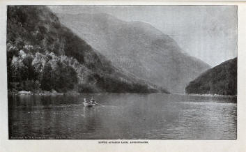
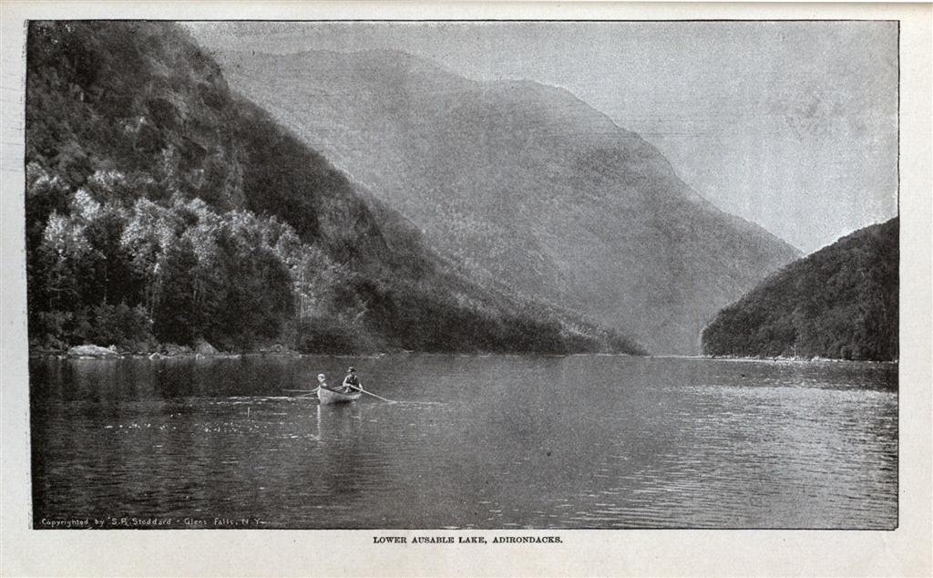
Health and Pleasure on
"America's greatest
railroad":
Descriptive
of Summer Resorts and
Excursion Routes,
Embracing More Than One
Thousand Tours

- Ronni
Toledo
In the section on
American resorts in the
fifth issue of the
promotional series, Health
and Pleasure on “America’s
Greatest Railroad”, the New
York Central and Hudson
River Railroad Company
characterizes the Adirondack
Mountains as the “nation’s
pleasure ground and
sanitarium”. The description
of the region outlines the
myriad of benefits that the
New York wilderness confers
upon visitors; most
importantly, the opportunity
to unite with nature and be
restored to health and vigor
by the “soothing properties
of the balsamic air”[1]
After five pages of lofty,
detailed claims about the
beauty and value of the
region, the authors finally
express their true
intentions: to publicize the
opening of the Adirondack
and St. Lawrence Lines, two
of the only—and certainly
most convenient—ways to get
to the mountains and to
experience the tranquility
of the wilderness.
Published in 1893, the same
year that Turner delivered
his paper on the
significance of the
frontier, the part on the
Adirondacks agrees with
Turner’s description of the
frontier as a place where
man can escape the shackles
of civilization and return
to a more “basic state”. The
rest of the section,
however, offers a
representation of the
frontier that differs
significantly from Turner’s.
Turner suggests that the
frontier forces people to
abandon the metropole
entirely and to confront the
savagery of nature. Such a
process supposedly leads to
the creation of the American
identity since men must
learn to survive in a
completely different
environment. The Railroad
Company on the other hand,
merely encourages people to
take a temporary sojourn to
the Adirondacks; enough to
become reinvigorated, but
certainly not the length of
time required to form a
completely new identity.
Furthermore, while visitors
may acquire more strength
and individualism on their
short trips to the
Adirondacks, the Railroad
Company places much more
emphasis on the peacefulness
of the region and the
physical and mental
rejuvenation that the
mountains supposedly
provide, whereas Turner
assumes that man must face a
number of threats to his
existence on the frontier.
The Railroad Company may
have faced Turner’s frontier
while constructing the
lines, but their
advertisements for the lines
suggest that the railroad
transformed the region into
one of safety and beauty.
Ironically, the company
repeatedly claims that the
land upon which the lines
lay remains untouched and
untainted by human
intervention. The authors
essentially suggest that the
railroad enables Americans
to explore the regions that
Turner claims no longer
exist and to acquire
somewhat similar, if not
superior, benefits, while
avoiding “the fatigue and
hardships encountered in the
past”[2]
Notes:
[1] The New York Central
& Hudson River Railroad
Company,
Health and Pleasure on
"America's Greatest
Railroad": Descriptive of
Summer Resorts and Excursion
Routes, Embracing More Than
One Thousand Tours (New
York: New York Central &
Hudson River Railroad Co.,
1893), 114.
[2] Ibid., 115.
Return to Top
|
|
Reports of Explorations
and surveys:
to ascertain
the most practicable and
economical route for a
railroad from the
Mississippi River to the
Pacific Ocean. Made under
the direction of the
secretary of war, in 1853

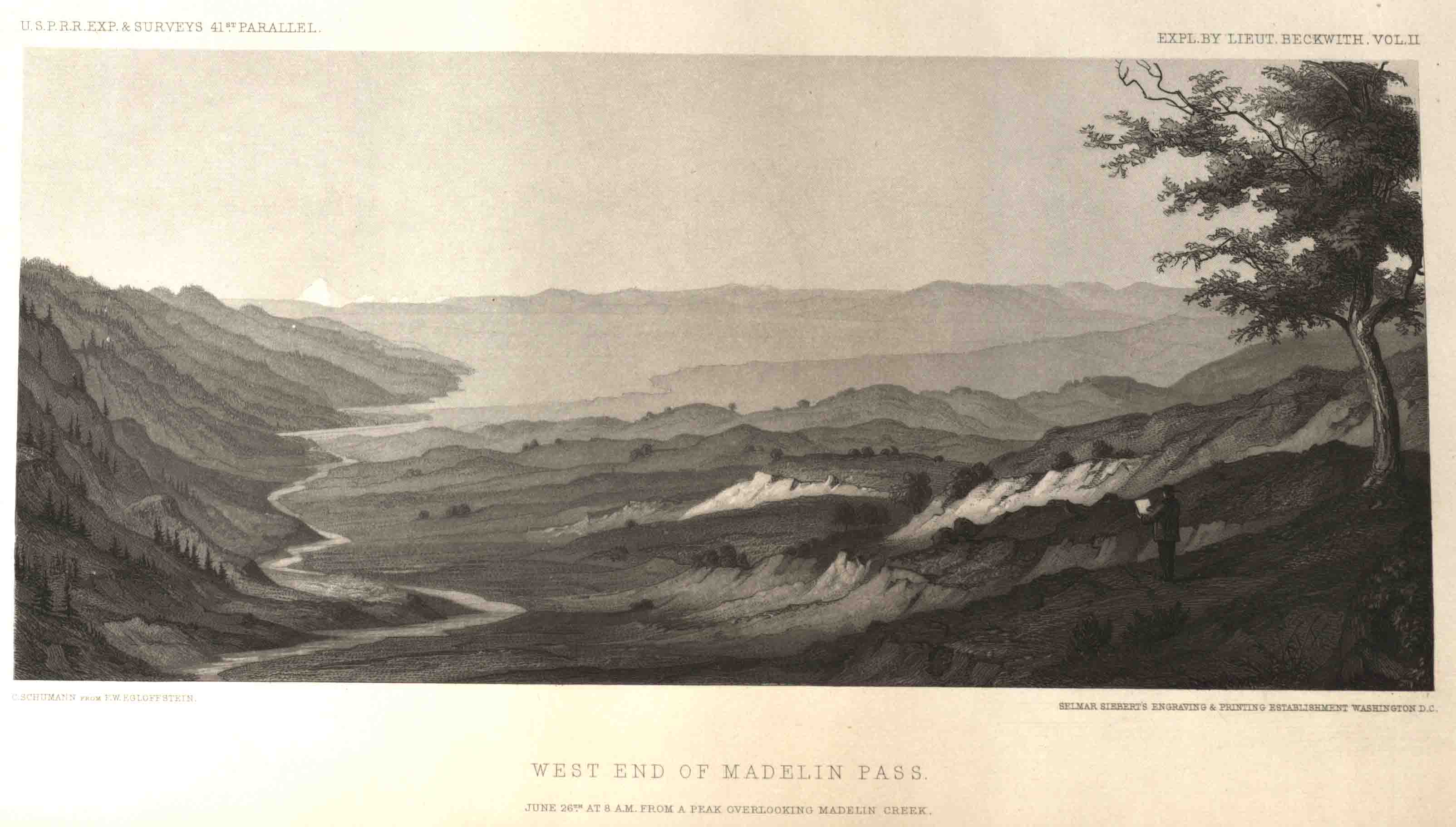
- Kayt Fitzmorris
The
United States War Department
Reports of Explorations and
Surveys, Volume Eleven, was
created to “represent only
such portions” of the
western territories “as have
been actually explored, and
of which our information may
be considered reliable"[1]
in order to be reviewed by
the United States War
Department in preparation
for building railroads from
the East to the West.
Compilers of the reports,
Lieutenant G. K. Warren
especially, emphasized the
objective quality of
selecting explorers’
accounts, maps, and images
from which to form an
accurate account of the land
between the Mississippi
River and the Pacific Ocean.
In the collection are not
only topographical accounts
and maps, but also several
accounts of explorers’
experiences on the frontier.
Lieutenant Warren included
these accounts in order to
“promote the consultation of
the original reports and
maps, by pointing out to
each investigator those
works which probably contain
information about the region
of country especially
interesting to himself.”[2]
Despite his emphasis on
accuracy and objectivity
described in the beginning
of his introduction,
Lieutenant Warren also gives
value to the personal
accounts and biases that
come with exploring the
frontier. This subtle
boosterism for the territory
can also be seen in the
images included in the
volume. In several of the
detailed sketches of the
territory between the
Mississippi and the Pacific,
the foreground of the image
features people looking out
across the land. In some,
Indians survey the territory
while in repose. In others,
European explorers decorate
the foreground, eyeing the
undeveloped territory
confidently.
Lieutenant Warren’s report
accomplishes two things:
describing the territory in
preparation for the
cross-country railroad, and
highlighting the frontier as
a place of adventure and
beauty. His choice to
include accounts of American
explorers on the frontier is
reminiscent of Frederick
Jackson Turner’s belief that
a true American is a product
of his
surroundings—transformed by
the frontier after leaving
the east behind. In this
book the railroad presents,
although subtly, the
opportunities for developers
and builders to access this
wild frontier, becoming more
American as they travel
west.
Return
to Top
|
|
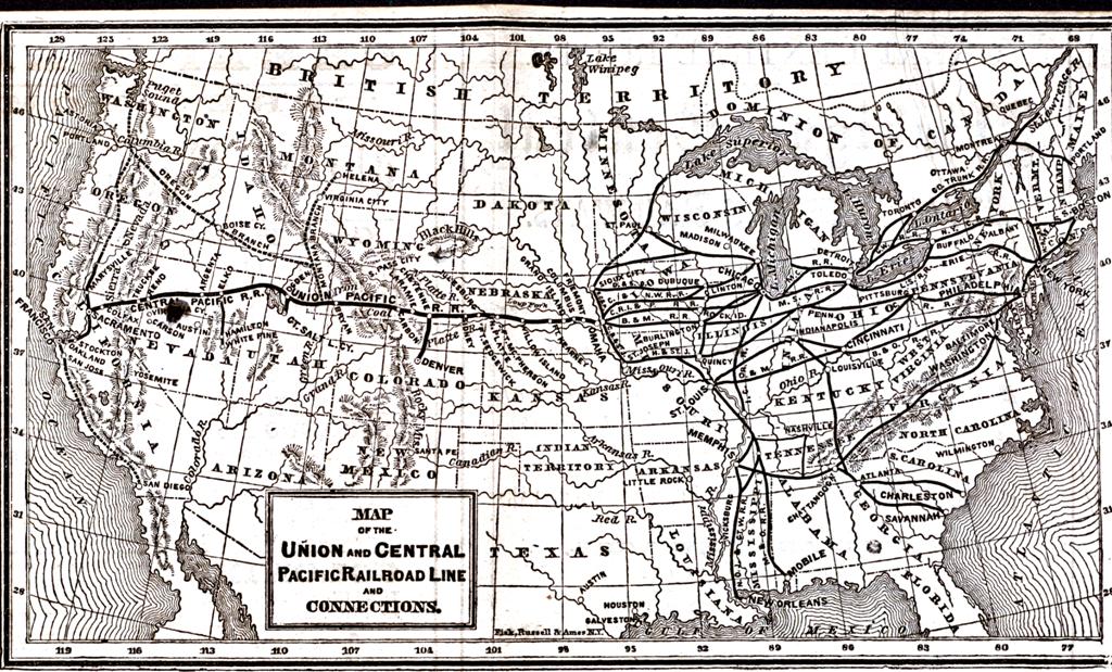
Crofutt’s
Trans-Continental
Tourist’s Guide

- Jon Ingram
The travel guide is
a portable book in which the
author gives detailed
information on the
trans-continental railroad.
Specifically, the text
focuses on the numerous
stations and stops along the
way, giving information
regarding them and the
surrounding area. This book
details not only what was
important to the writers of
the book, but what they
would have wanted people
traveling to know or what
was to be found along the
way. In this, the book
begins with descriptions of
western regions (Northeast,
Far West, etc) and gives
depictions of them and the
grandeur to be found.
Essentially, the book aims
to promote the railroad,
give incentive to travel
westward, and portray the
trans-continental as the
conduit to the west. The
second section of the text
gives a rather romanticized
version of how the rail line
came to be built, hearkening
back to the Civil War, and
showing the US in an
expansionist, nationalistic
light. The wording and
images indicate the heavy
prevalence of Manifest
Destiny that people still
felt at the time about the
frontier. In this light, the
Union Pacific railroad is
specifically mentioned. A
detailed history and summary
of its setup and the working
of the company is given as a
promotional review and
advertising can be found for
its railcars (particularly
the sleeper cars) as the
best options for travelers.
Much of these two sections
seem to revolve around the
tourism aspect of the guide,
using self promotion and
lofty descriptions to make
their points. Inserted into
this are detailed sketches
of the rail line, showing
the trains and the landscape
of the west, using them as
selling points and creating
the idea that the traveler
wants to be there looking
out at these areas from the
train.
Lastly, the
majority of the tourist
guide revolves around the
short summaries it contains
on the majority of station
stops along the way,
national parks, and features
of the landscape. What is
interesting is that while it
is classified as a
“tourist’s guide”, it does
not provide information for
the most part on what the
stops contain in the way of
food, lodging, or other
basics. Rather the train is
the focal point for these
necessities while the
landscape and what the train
passes through becomes the
focus. In a way, the
trans-continental at this
time is basically just a
corridor passing through the
frontier, but in the
descriptions we can see how
tourism will develop, such
as how Yellowstone is
referenced and how later
guides will include things
to do along the way. This
section is summed up by
category and alphabetical
order by the authors for
quick reference by page
number,in order that one
might quickly reference a
specific location. Ideally,
each description contains at
least several facts,
details, or points of
interest. For instance,
interesting occurrences,
land features, events, or
what the area specializes in
(cattle, grain). Every step
of the way is detailed with
tourist and factual
information with the
ultimate goal of California
being consistently present.
The theories of Fredrick
Jackson Turner are
consistent with this as the
West is shown as the escape
from the city. The west here
is the answer to improving
one’s life and forming a new
start, while everything
along the way is secondary
and just part of the
journey.
Return
to Top
|
|
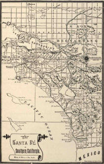
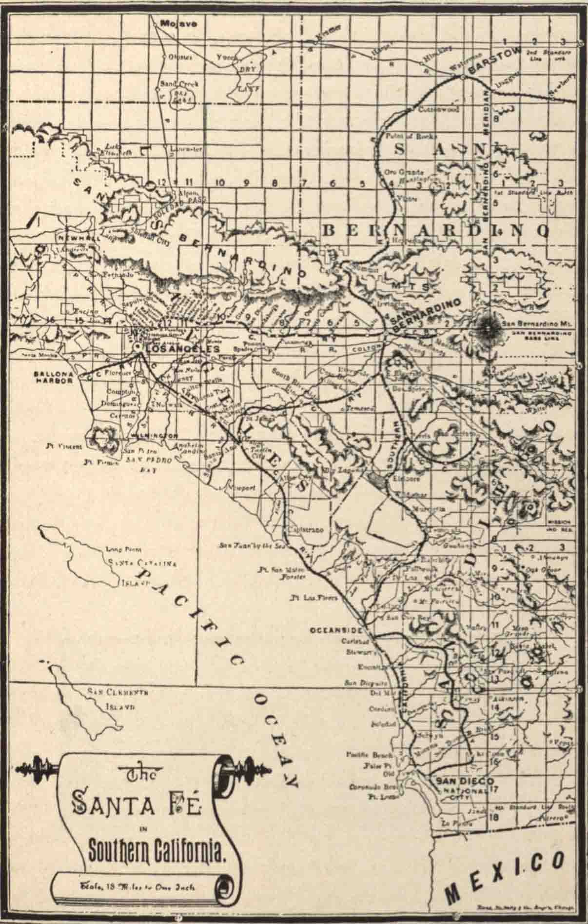
Rand, McNally & Co.'s
new guide to the Pacific
coast : Santa Fé
route: California,
Arizona, New Mexico,
Colorado, and Kansas

- David Halperin
Frederick Jackson
Turner describes the
American frontier as
“sharply distinguished from
the European frontier – a
fortified boundary line
running through dense
populations." [1] When it
comes to the history of the
western railroads in
California, one does begin
to see a noted boundary
line, yet the dense
population he spoke of did
not begin here, but rather
in Southern California. In Rand,
McNally & Co.’s Guide
to the Pacific Coast
(published during the same
year Turner delivered his
frontier speech), the
travel guide lists numerous
facts about the west,
stretching from Kansas to
California. Though the most
elaborate account of a
frontier-like state comes
when it describes the
junction at the small,
almost non-existent, town of
Needles, CA.
“Here,
the cars destined for Los
Angeles and San Diego turn
directly southward. It is
the end of the desert. By a
contrast and transition so
striking as to be almost
marvelous, you stand at this
lonely little desert station
almost upon the verge of a
country where all the
products of two zones grow
side by side, with a
luxuriance unknown elsewhere
on the globe, and beneath a
climate that within the past
five years has attracted
tens of thousands of
permanent residents." [2]
Clearly
this was a significant
landmark for both the
railroads and for western
migrants looking to
capitalize on a more
prosperous life in this new
and desirable climate.
Furthermore, though
California had existed as a
singular state since 1850,
there were increased
observations of the
differences between the
northern and southern
sections. When California
became a popular travel
destination the differences
noted between the two areas
allowed for a new,
Postcolonialist way of
identifying what
constitutes as foreign and
domestic. [3] This concept
is brought forth in the
travel guide book, which
explains that “Indeed it
may almost be said that
everybody, in California
or out of it, regards the
two sections as entirely
distinct…The distinction
has produced a ‘boom’ in
which the northern
three-fourths of the State
has not shared." [4] By
sending the trains all
across the state, the
respective populations
unquestionably developed
sharp contrasts to one
another as new groups such
as Los Angeles boosters
could now, for example, be
contrasted to northern
Californians with
different political
agendas.
In conclusion, the Rand,
McNally & Co. guidebook
serves not only to
physically map out the west,
but to encourage the curious
traveler to make the journey
to a rapidly expanding land.
As Richard Francaviglia duly
notes, “...maps are tools of
the spirited mind—the empire
builder and the storyteller:
they fuel the desire to
experience, even claim, the
geographic area that they
represent." [5]
The
guidebook clearly serves
to present nature and
the human response to
nature through the
railroad’s crossing of a
small, but mighty,
boundary in California.
[1] Turner,
Frederick Jackson. “The
Significance of the
Frontier in American
History.” American
Historical Association
(Washington DC) 1893.
(Page 3)
[2]
Steele, James W. Rand,
McNally & Co.'s
New Guide to the
Pacific Coast: Santa
Fé route:
California, Arizona,
New Mexico, Colorado,
and Kansas.
Chicago; and New
York: Rand, McNally
& Co., 1893, c1888.
(Pages 129-130)
[3] Axelrod,
R.B. & Axelrod,
J.B.C. Draft of
“Postcolonialism.” W.W.
Norton & Company,
Inc. 2004-2009. (Page
18)
[4] Steele,
James W. Rand,
McNally & Co.'s
New Guide to the
Pacific Coast: Santa
Fé route:
California, Arizona,
New Mexico, Colorado,
and Kansas.
Chicago; and New
York: Rand, McNally
& Co., 1893, c1888.
(Page 143)
Return to Top
|
|
About
this Project / Acknowledgements
Occidental
College's "American Frontier"
Research Seminar was developed by
Dr. Jeremiah B.C. Axelrod, Adjunct
Assistant Professor of History.
The library project
is developed in collaboration with
the Special Collections
Department:
Dale Ann Stieber, Special
Collections Librarian
with student staff
Henry Boule and Claire Lem and
Laila Tootoonchi and Anahid
Yahjian.
Title Image:
Thomas Moran, "Nearing Camp,
Evening on the Upper Colorado
River, Wyoming, 1882," from
http://www.boltonmuseums.org.uk/collections/art/paintings_prints_and_drawings/oil/nearing_camp_moran
|
|
Page last edited on 03/12/2013.
Occidental
College Library Special
Collections & College Archives
© 2009 Occidental College
|
|
|
|
|